Get COVID-19 number information down to the postal code.
 The PA State Department of Health (DOH) has expanded it’s county-by-county map of COVID-19 information to include cases by zip code.
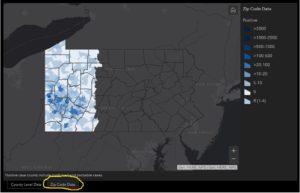
The break down begins with a colorization of each county and a key showing what each color means. You can then select a county and get the number of cases along with the count of negative tests and the number of deaths, if any.
By selecting zip code at the bottom, you can narrow it down to the postal code. For example, the 15851 postal code in Jefferson County, which includes the Reynoldsville area, shows zero cases and 28 negative results.
Yesterday, the graphic showed that Jefferson County COVID-19 positive cases increased by one to stand at three. It remains that way today, but state cases have increased to a total of 34, 528 cases and 1564 deaths. The information is updated daily at noon.
To access the map, click here.